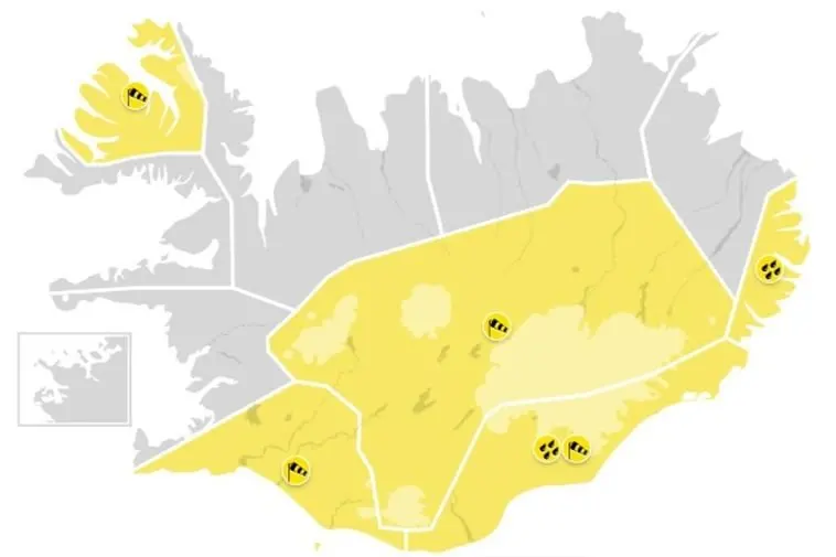
A bout of wild September weather is sweeping across Iceland today, with yellow warnings in force for large parts of the country. Strong easterly winds and heavy rain have prompted the Icelandic Met Office to alert residents and travellers from the south coast all the way to the Westfjords.
The most serious alert covers South Iceland, where winds of 18-25 m/s are forecast, with gusts topping 35 m/s around Eyjafjöll and the Westman Islands. That warning runs from 6 a.m. until noon, and authorities are asking people to secure anything loose outdoors — trampolines, garden furniture, the lot. Southeast Iceland and the central highlands followed at 7 a.m. In the southeast, gusts above 35 m/s are expected west of Öræfajökull and in Mýrdalur, an area that includes popular stops on the ring road.
Rain is the other half of the problem. Considerable to heavy rainfall is forecast for the southeast, raising the risk of flooding and landslides that could disrupt transport — worth knowing if you are driving between Vík and Skaftafell, where rockfalls occasionally close the road. A separate heavy-rain warning kicks in for the Eastfjords at 9 a.m.
The central highlands look the least inviting. Winds there are expected to hit 20-28 m/s alongside significant rain and rising water levels, and the Met Office advice is blunt: do not travel. If you had a highland day trip or a Landmannalaugar detour booked, today is the day to rearrange it.
Later in the day, the Westfjords come into play, with a storm warning for northeasterly winds from 3 p.m. The good news is that the strong easterlies elsewhere should ease considerably after noon, though the Westfjords stay blustery.
Looking ahead, tomorrow brings northerly winds of 13-20 m/s to the northwest with rain or sleet and mountain snow, while the south and east get lighter westerly winds and patchy precipitation. Temperatures today sit between 5°C and 11°C, dropping to a 3°C to 13°C range tomorrow — coldest in the Westfjords, warmest in East Iceland.
If you are in Iceland right now, the practical takeaway is simple: take it slow, check road conditions on road.is and updates from the Icelandic Met Office before setting out, and avoid highland routes entirely until warnings lift. Campervans, caravans and anything tall on wheels are particularly vulnerable to crosswinds, so ring-road drivers should be extra careful on open stretches of the south coast. Sights like waterfalls and glacier viewpoints are best saved for once the wind drops — gate closures during storms are not uncommon. Iceland's weather changes fast, and a rough morning often turns into a calm, clear afternoon, so there is a decent chance the second half of today works out fine for sightseeing in the south.