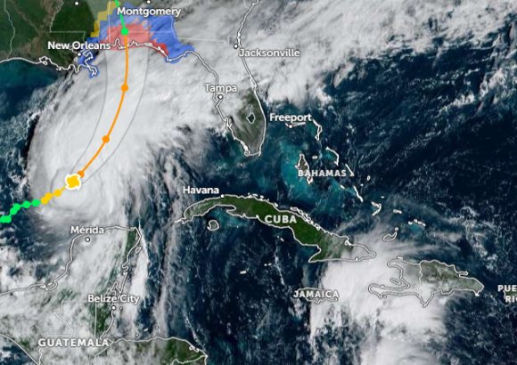
Good news for anyone with a Caribbean trip on the books: Hurricane Isaias strengthened to Category 1 on Thursday, but the Dominican Republic sits well outside its projected path and faces no direct threat from the storm.
The US National Hurricane Center placed Isaias roughly 280 kilometres northeast of Progreso, Mexico, chugging east-northeast at 15 km/h with maximum sustained winds of 130 km/h and a central pressure of 975 millibars. Forecasters expect the system to swing north, pass above the Yucatán Peninsula, and make landfall on the northern Gulf Coast late Friday or early Saturday — possibly a bit stronger by then.
The people who do need to pay attention are along the US Gulf. Hurricane and storm surge warnings are up for parts of the Mississippi and Florida coasts, with tropical storm warnings stretching across sections of Louisiana and Florida. The NHC flags dangerous storm surge, hurricane-force winds and heavy rain, with flash and urban flooding possible across the central Gulf Coast and the Southeast. If you have flights or beach plans in those states this weekend, expect disruption and check with your airline or hotel before travelling.
As for the Dominican Republic itself, the weather story there is an ordinary tropical wave rather than a hurricane: showers, thunderstorms and gusty winds are likely in parts of the southeast, southwest, the Central Mountain Range and Greater Santo Domingo. Authorities are asking residents to watch for localised flooding during heavier downpours. Otherwise it's classic Caribbean heat — highs of 33 to 35°C, with the usual advice to drink plenty of water, dress light and stay out of the midday sun.
For travellers, the takeaway is simple: Punta Cana, Santo Domingo and the rest of the country are operating normally, though it's always smart to keep an eye on updates from Dominican meteorological officials during hurricane season, since tropical systems can shift. The real risk zone for this storm is the US Gulf Coast, not the eastern Caribbean.