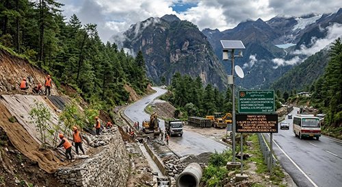
Anyone who has travelled by road in Bhutan knows the drama: steep passes, hairpin bends above river gorges, and the occasional landslide that turns a four-hour drive into a full-day wait. Now the country's Ministry of Infrastructure and Transport is tackling the problem at its roots, and the changes could make a real difference to how visitors plan their trips.
Speaking at the 32nd Meet-the-Press, MoIT Secretary Karma Wangchuk said simply clearing blocked roads after landslides wasn't enough — the ministry is now focusing on prevention. That means better drainage, stabilising slopes and smarter maintenance along key corridors, especially the busy Wangdue Phodrang to Thimphu highway that most travellers use between the capital and the valleys of Punakha and Phobjikha.
The technical fixes are substantial. New and upgraded roads must now be designed for 20 to 25 percent more rainfall discharge than before, with at least five cross-drainages per kilometre, each at least 1.2 metres wide. Landslide-prone spots are logged in a national Road Slope Failure Database, and stabilisation guidelines were developed with Japan's JICA under the 2024 C-Slope Project, covering everything from rockfalls to debris flows. On high-altitude sections like the famous Dochula pass at 3,100 metres, freeze-thaw damage is being studied through trial pavement stretches on the Dungdungneysa–Pelela section of the Wangdue–Chuserbu highway.
The most traveller-relevant piece is the early warning system. Rainfall and slope movement at hazard-prone locations are monitored in real time, feeding into a Road Slope Warning System at the Department of Surface Transport. When thresholds are exceeded, traffic on dangerous stretches can be stopped before a landslide happens. During the monsoon, heavy equipment is pre-positioned at trouble spots, and 18 sets of Bailey bridge parts are stockpiled at regional offices for quick repairs to damaged crossings.
For up-to-the-minute conditions, travellers can follow the Bhutan Road Watch App, the DoST Facebook page and official messaging groups, where designated officials post the location of blockages, the cause, estimated clearance times and reopening news.
Why does this matter to visitors? Bhutan's tourism model is built around guided itineraries that move by road — Thimphu to Paro, Punakha, Bumthang and beyond — so a single landslide can derail a tightly planned trip. Reliable early warnings, faster clearance and the Bhutan Road Watch App give travellers and tour operators better tools to reroute or retime journeys during the June-to-September monsoon, which is precisely when most road closures happen. It's also a signal of how seriously Bhutan is taking climate resilience as rainfall intensifies in the Himalayas.
If you're travelling in monsoon season, build buffer time into your itinerary, check Road Watch updates each morning before setting out, and ask your operator which sections of your route are most landslide-prone. The highways are improving, but the mountains still set the schedule. — The Bhutanese